


Howell township voting district 7, Monmouth County, New Jersey
About
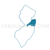
Outline

Summary
| Unique Area Identifier | 620446 |
| Name | Howell township voting district 7 |
| County | Monmouth County |
| State | New Jersey |
| Area (square miles) | 3.67 |
| Land Area (square miles) | 3.64 |
| Water Area (square miles) | 0.03 |
| % of Land Area | 99.21 |
| % of Water Area | 0.79 |
| Latitude of the Internal Point | 40.13168620 |
| Longtitude of the Internal Point | -74.16563870 |
Maps


Graphs
Select a template below for downloading or customizing gragh for Howell township voting district 7, Monmouth County, New Jersey


Neighbors
Neighoring Voting District (by Name) Neighboring Voting District on the Map
- Howell township voting district 1, Monmouth County, NJ
- Howell township voting district 15, Monmouth County, NJ
- Howell township voting district 26, Monmouth County, NJ
- Howell township voting district 3, Monmouth County, NJ
- Lakewood township voting district 10, Ocean County, NJ
- Lakewood township voting district 13, Ocean County, NJ
- Lakewood township voting district 25, Ocean County, NJ
- Wall township voting district 2, Monmouth County, NJ
Top 10 Neighboring County Subdivision (by Population) Neighboring County Subdivision on the Map
- Lakewood township, Ocean County, NJ (92,843)
- Howell township, Monmouth County, NJ (51,075)
- Wall township, Monmouth County, NJ (26,164)
Top 10 Neighboring Place (by Population) Neighboring Place on the Map
Top 10 Neighboring Elementary School District (by Population) Neighboring Elementary School District on the Map
Top 10 Neighboring Secondary School District (by Population) Neighboring Secondary School District on the Map
Top 10 Neighboring Unified School District (by Population) Neighboring Unified School District on the Map
Top 10 Neighboring State Legislative District Lower Chamber (by Population) Neighboring State Legislative District Lower Chamber on the Map
Top 10 Neighboring State Legislative District Upper Chamber (by Population) Neighboring State Legislative District Upper Chamber on the Map
Top 10 Neighboring 111th Congressional District (by Population) Neighboring 111th Congressional District on the Map
Top 10 Neighboring Census Tract (by Population) Neighboring Census Tract on the Map
- Census Tract 7152, Ocean County, NJ (12,765)
- Census Tract 7153.01, Ocean County, NJ (9,272)
- Census Tract 7150, Ocean County, NJ (8,890)
- Census Tract 8115.01, Monmouth County, NJ (6,406)
- Census Tract 8112, Monmouth County, NJ (5,513)
- Census Tract 8087.02, Monmouth County, NJ (3,977)
- Census Tract 8115.02, Monmouth County, NJ (3,620)